About Me

My photo
Hello! My name is Keith Gault and I've been tramping the hills of the UK and further afield for over 40 years now. This blog records some recent hill days undertaken either on my own, with friends, or with clients under my guided hillwalking Company: Hillways (www.hillways.co.uk). I hope you enjoy my diary; please feel free to comment on any of the walks. I will respond to any direct questions.

Saturday, 17 May 2014

Skye 2014


Matt, Tying His Shoelaces...I Think!

This year’s Hillways visit to the Misty Isle resulted in 2 testing days on the Cuillin Ridge, Matt climbing the Inaccessible Pinnacle with Darren from Hebridean Pathways ( http://www.hebrideanpathways.co.uk ) and 3 mainland days avoiding the worst of the weather.

Sgurr nan Gillean


Sgurr nan Gillean & Am Basteir

Day 1 dawned ‘OK’ so we chose one of the more challenging Cuillin peaks and one that for many, defines these mountains: Sgurr nan Gillean.  This dark shapely spire dominates the view from the Sligachan Hotel (on at least 10 days of the year anyway) and appears to offer no easy access to the hillwalker.  There is a way though, one that traverses the E slopes of the mountain and gains the summit by way of the reclusive SE ridge.


Sgurr na h-Uamha & Lota Corrie

With the upper part of the peak shrouded in cloud, we set off from the Slig along the well-worn path that leads across the heather, grass and bog.  An hour out and you reach a cairn marking a fork in the path.  Here, we veered left into Coire Riabhach before the climbing started in earnest.  The path snakes its way up and across the scree and boulder fields before emerging on the skyline where Lota Corrie suddenly appears directly below you. 


The SE Ridge of Sgurr nan Gillean

Here we entered the cloud and began our rock-hopping traverse of the SE ridge which appears to climb exponentially up to the unseen summit.  There’s some steep  rock slabs to negotiate just below the cairn so go carefully here before you pop up on the crest some 30 yards short of the rather modest cairn.  A couple of minutes of mind-absorbing exposed scrambling will get you your Munro: Sgurr nan Gillean (964m; peak of the young men).


The Summit

We returned the same way, the cloud slowly lifting until all the tops were clear.  The Slig takes forever to arrive, but when it does the chips are very nice…..


Out of the Cloud in the Descent 

Sgurr nan Eag, Sgurr Dubh Mor & Sgurr Alasdair

Day 2 was again ‘OK’, at least to begin with…  So we positioned ourselves at the other end of the ridge from yesterday and set off from Glenbrittle to tackle the 3 southern-most Munros of the range.  It takes about 2 full hours to traverse the open hillside and negotiate the ice-scoured bedrock that leads to the eponymous lochan that nestles high up in Coir’ a’ Ghrunnda.  It’s worth it though as the rock amphitheatre that awaits you is quite special (and very rocky)!


Coir’ a’ Ghrunnda

A straightforward scree path (can’t say that very often about the Cuillin) leads SE up a steep slope to deposit you on the Skye Ridge itself.  We climbed this in cloud and once up, followed the uncharacteristically broad ridge for 10 mins to reach the southern-most Cuillin Munro: Sgurr nan Eag (924m; peak of the notches).  This peak is the only summit on the main ridge with any appreciable width; accordingly, it sports the biggest cairn!


Sgurr nan Eag Above Coir’ a’ Ghrunnda

We retreated back down the path until half-way towards the lochan before traversing right and regaining the ridge high above An Garbh-choire.  Traversing past the base of the rock tower of Caisteal a’ Garbh-choire, we paused for lunch before scrambling up rock slopes that lead to Sgurr Dubh na Da Bheinn.  Placing your compass on the summit rock here will induce the needle to find its very own magnetic field so keep it clear of the ground if using it in anger!


Sgurr Dubh Mor & Sgurr Dubh na Da Bheinn

Here we left the main ridge for the obligatory diversion E to pick up Munro No 2.  It’s a fairly uncomplicated scramble down to the intervening bealach but the subsequent re-ascent of Sgurr Dubh Mor is complicated and it helps to know the way.  A series of ledges traverse this side of the mountain and the trick is knowing when to change levels.  The summit is one of the narrowest in the Cuillin and the cairn appears to cling to the very top of the mountain: Sgurr Dubh Mor (944m; big black peak).


Sgurr Alasdair FromSgurr Dubh na Da Bheinn

Dark clouds had begun to gather over the ridge as we returned to Sgurr Dubh na Da Bheinn.  Inevitably perhaps, given our luck thus far, these started to unleash steady drizzle by the time we were traversing below our final peak of the day, Sgurr Alasdair.  If Matt & Jenn found the access chimney entertaining, they did very well to conceal their mirth as they slithered up the dark and dank chute.  Even more dark entertainment followed as we picked our way oh so carefully up the slippery, shattered and crumbling gabbro slopes of the Black Cuillin’s crowning peak: Sgurr Alasdair (992m; Alexander’s peak).  Navigation for the other 2 was greatly eased by the trail of blood I was laying down for them as a surprising amount of the red stuff dripped with alarming ease from a small finger wound I incurred somewhere on the ascent!


Traversing Below Sgurr Alasdair

A challenging climb, pouring rain and a gushing (honest, Mum) blood wound all encouraged the shortest of stops on top and we were quickly on our way down the short, but delicate, ridge to safer ground.  We now stood at the top of our descent route - the Great Stone Shoot.  This mighty chute of slippery unstable rock, stones and shale requires care and attention to negotiate and should not be considered a rapid down-escalator with which to escape from the main ridge.  Accordingly, we picked our way down carefully into the heart of Coire Lagan where we paused to lick our wounds and gather ourselves for the final hour’s walk down the path to Glenbrittle.


Coire Lagan and That Stone Shoot Thing!

This is always a big day.  Today, it felt huge!

Maol Chean-dearg


Maol Chean-dearg From Liathach

By way of a change from dancing on slippery rock slopes, we drove to the mainland to resume Matt & Jenn’s mainland Munro quest.  An hour took us to Coulags near Lochcarron for their 2nd attempt at Maol Chean-dearg.  The last time they were here, Matt suffered crippling back spasms that terminated their ascent leading to a very slow and painful retreat.  I think it was bad for Matt too…


Sgorr Ruadh & Coire Fionnaraich Bothy

Today, a dull, dry and overcast morning saw no such repeat and an injury-free walk up the excellent path into Coire Fionnaraich.  The old landmarks in this very familiar glen were still all here for me - the bridge over the Fionn-abhainn, Coire Fionnaraich bothy and Clach nan Con-fionn.  The latter (the stone of Fingal’s dog) is where our legendary hero reputedly tethered his hunting hounds - so now you know!  


An Ruadh-Stac

An hour from the car, we reached the cairn marking the junction between corrie and hill paths.  We started up the latter making good time until we cut the corner off via the quartzite boulder field where we made less good time!  At least we were spared the steep shaley scramble up the normal route (as well as a little distance) and were soon climbing the sandstone summit mound that gives the mountain its name.  The summit itself is flat and crowned by a huge cairn.  Torridon lay beneath our feet and the view north was bedecked by the best mainland mountains in the country.  Maol Chean-dearg (933m; bald red head).


Beinn Damh From Maol Chean-dearg

We returned via the normal route, gingerly descending the steep quartzite shale nose that leads down to the Bealach a’ Choire Ghairbh.  The compensation for this is the fine view of that equally fine Corbett: An Ruadh-Stac.  We made it back to the car just as the rain started.  What skill!

Beinn Fhada & A’ Ghlas-bheinn


Gleann Choinneachain

Continuing bad weather on Skye enforced the postponement of Matt & Jenn’s last 2 Cuillin Munros so we returned to the mainland to tackle 2 always-enjoyable Kintail Munros: Beinn Fhada and A’ Ghlas-bheinn.  Starting from my own favourite discrete car parking spot in Strath Croe, we climbed up through Gleann Choinneachain and the excellent stalker’s path that leads into Coire an Sgairne. 


Beinn Fhada From A' Ghlas-bheinn

Once on the summit plateau, it was an easy stroll through a couple of remaining  snowfields before the summit trig point appeared out of the mist and we were back on top of one of my favourite Munros: Beinn Fhada (1032m; long hill).


Approaching the Gates of Affric

Returning the same way took us to the Bealach an Sgairne - the Gates of Affric - and lunch.  From here, with clear views across the bleak bog-land of upper Glen Affric, we started up the seemingly unending path that twists and turns its way up the S ridge of what was to be our last Munro of the week: A’ Ghlas-bheinn (918m; greenish-grey hill).


A' Ghlas-bheinn

From a cloudy summit, we headed W descending easy slopes that lead to the shoulder of A’ Mhuc.  The clouds finally cleared to reveal the green upper reaches of Strath Croe which we reached via steep grassy slopes that drop directly to a forestry track.  The track led us back to the car through delightful mixed woodland to the welcome accompaniment of a babbling burn and sweet birdsong.

Coire Lair


Fuar Tholl From Achnashellach

Skye was out again so for our last day, we planned to drive to Achnashellach and climb the peaks of the Coulin Forest.  Unfortunately, an unhelpful forecast of 65mph winds proved to be somewhat optimistic and we only managed to get as far as the entrance to Coire Lair before we bowed to the inevitable and returned safely to the glen.  As we did so, a walker emerged from the direction of the hills to tell us he had been blown over at least once trying to reach the first peak and had experienced some difficulty trying to get back up.  That’s all we needed to know!


Coire Lair

   
Check out my plans for this coming year at: http://www.hillways.co.uk/uk/

Monday, 21 April 2014

The Crianlarich & Killin Hills


Ben Challum, Glen Lochay

Gorgeous weather over the Easter weekend helped Jennifer & Matt achieve their goal of 7 Munros in 4 days  from our Killin base.  There was still a fair bit of snow about, generally high up on N and E aspects, but the crust was soft enough not to cause problems.  We did carry crampons on a couple of the days though.   

Beinn a’ Chroin & An Caisteal


An Caisteal

These 2 hills form the central pairing of a group of 5 Munros that constitute the Crianlarich hills.  Having climbed all 5 in one go on previous visits, it was a refreshing change to adopt a more normal approach and climb just 2 of them in a single day.


Coire Earb

We started from near Keilator on the A82 just S of Crianlarich.  The 180m high start was very welcome on a sunny, cloudless morning as we followed the infant River Falloch up Coire Earb on a good track.  Alas the track soon runs out and the going becomes quite boggy thereafter.  A confluence of burns below the obvious nose of Stob Glas Bheag directly ahead provides a scenic stopping point for refreshment.  We took full advantage of the setting!  Then it was the first climb of the trip, up the aforementioned Stob that guards the N ridge of Beinn a’ Chroin and up on to the summit ridge of this fine wee hill.


Beinn a' Chroin

The mountain has 3 summits the highest of which is now belatedly recognised as the central one.  For many years, the E cairn had been the official Munro but that has now been corrected.  As always in these situations, it is wise to traverse all likely candidates in the event of a subsequent re-survey.  Thus we took in all 3 cairns and claimed our first Munro of the trip: Beinn a’ Chroin (942m; hill of the sheep fold).


Beinn a' Chroin & An Caisteal From Coire Earb

The traverse of all 3 tops is no chore as the summit ridge of the mountain is a pleasantly undulating collection of humps and dips with no great change in elevation.  Things change at the W end however, as steep craggy slopes drop abruptly to the Bealach Buidhe.  The path is clear though and careful negotiation is all that’s required to attain the relative sanctuary of the bealach.  I saw an osprey fly by the last time I was here!


Summit Cairn, Beinn a' Chroin

From here, the climb up to the next Munro does go on a bit (particularly in cloud) and it’s a good half-hour before the slope finally flattens out and you arrive at the summit cairn of An Caisteal (995m; the castle).


Twistin Hill

After pausing to admire views from Glasgow to Ben Nevis and beyond, we headed down, traversing the appropriately – and delightfully – named Twistin Hill as it snakes its way N from the summit.  From the last rise on the ridge, Sròn Gharbh (709m), it’s downhill all the way but with no paths to assist, we made a beeline for the track bedside the River Falloch which led us back to the car.

Creag Mhor & Beinn Heasgarnich


Creag Mhor From Glen Lochay

These 2 relatively high and remote Munros sit rather inconveniently far up Glen Lochay and it’s a fair hike to capture them both.  Leaving the car at the new bespoke car park one kilometre short of Kenknock Farm, we traipsed off up the glen for some 6Km on the convenient farm track.  The shapely pyramid of Ben Challum, growing ever closer directly ahead, greatly enhances the scene.  Soon after Batavaime, the track splits and we took the right-hand fork that leads smartly up to intercept the hydro track that contours along the N-side of the glen.

 
Glen Lochay

Crossing this, we negotiated a new deer fence (some good work from the Forestry Commission here, planting up swathes of natural woodland) and headed towards the steep crags of Sròn nan Eun.  We aimed for the obvious swing gate - there is no path at first - and headed to the right where easier slopes afford access to the ridge-line.  Once up, the path finally appears and we followed this all the way to the summit cairn of Creag Mhor (1047m; big crag).


Creag Mhor

The safest way off this mountain is not straight over and down the very steep NE corrie, but to head W initially and follow the corrie rim around until gentler slopes can be traversed to the peaty 650m bealach before the next climb.  From Creag Mhor, the unrelenting slopes of Sròn Tairbh look as intimidating as they are unwelcome.   In reality, this crux of the whole day passes a little easier than you expect it to (honest…) and we were on the ridge in just over 30mins.  


Creag Mhor

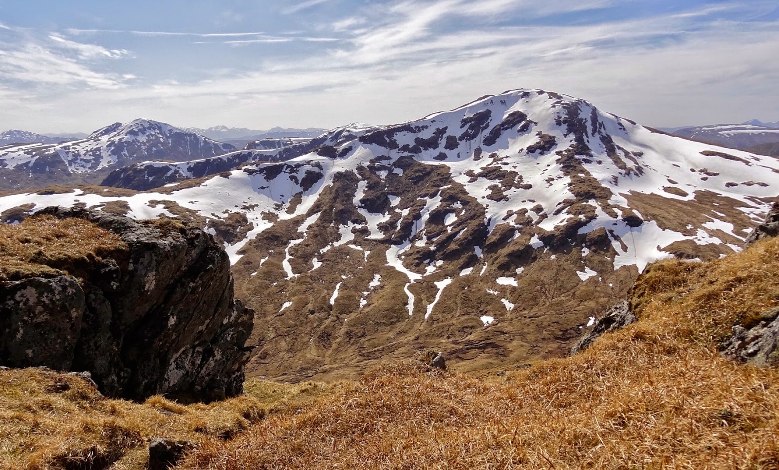
From here, almost level ground took us along the open ridge, contouring around the NW slopes of Stob an Fhir-Bhogha before turning N to reach the elusive cairn of Beinn Heasgarnich (1078m; peaceful hill).  This huge mountain, the highest of the Glen Lochay hills, is never easy and it’s a long way to anywhere from here!


Beinn Heasgarnich From Creag Mhor

We retreated SE, descending over numerous large snowfields until the hydro track came into view far below.  The best line is to aim directly for where the Allt Bad Odhar intercepts the track; this at least minimises the distance you have to travel.  The track is then followed at about the 375m contour, through several gates and over the conspicuous hydro pipeline, before descending down to the floor of the glen on the private road and back to the waiting car.  Those planning to complete this demanding day can expect to feel somewhat weary by the time you get there.

Stuc an Lochain & Meall Buidhe


Stuc an Lochain

For Day 3 we drove over to the head of Glen Lyon and parked at the Loch an Daimh dam.  Despite a cool breeze, it was still wonderfully blue and sunny!  I’ve generally done these hills the other way around, but today we agreed that the steepest hill should go first.  And so it was that we followed the road below the dam and along the loch for ½Km to where a small cairn marks the start of a steep path up into Coire Bàn.  It’s a bit brutal first thing in the morning, but you are starting from 410m so stop your whining and man up!  Before long, the slope relents and you are on the short E ridge of Creag an Fheadain (887m) which you follow to the cairn.  There are fence posts to help guide your way – as so often in this part of the world!


Lochan nan Cat

They certainly help with the sharp left turn at the cairn from where the morning’s Munro springs into view.  It’s a comfortable 2Km stroll around the wide corrie rim to the summit with Lochan nan Cat nestling below the summit cliffs to your right.  Today, the few remaining snow patches posed no difficulty and progress was swift.  The final climb to the top is straightforward and a clear path leads all the way to the cairn: Stuc an Lochain (960m; peak of the small loch).


Stuc an Lochain From Meall Buidhe

We returned the way we had come but avoided the car park before stopping for lunch at the foot of our 2nd hill of the day.  The light and colour looking over the loch and up the glen were spectacular and we didn’t rush lunch.  The start of the path was again marked by a small cairn at which point we left the track.  The route is boggy in places and a little indistinct.  You need to aim for a dip on the horizon immediately to the W of Meall a’ Phuill.  The skyline marks the corrie rim of Glas Choire which you follow up and over Spot Height 917m and then along a fairly level wide ridge for one final kilometre to the summit cairn of Meall Buidhe (932m; yellow hill).

 
Meall Buidhe

This remote Munro affords excellent views in clear weather and so it was today we were able to pick out the distant Cairngorms, Beinn a’ Ghlo and the distinctive hump of Ben Nevis across Rannoch Moor.  We returned the same way feeling rightly smug - if a little exhausted - with our haul of 6 Munros in 3 days!

Meall nan Tarmachan


Meall nan Tarmachan From Killin

Prior to driving home, Jenn & Matt were quite keen to capture one more Munro.  It had to be short and sweet and in these parts there is but one obvious candidate: Meall nan Tarmachan.  We were away from the car at a little after 9AM and the combination of high start (460m) and short route resulted in a rapid and successful ascent.  Even the pesky snowfields guarding the summit couldn’t deny us Meall nan Tarmachan (1044m; hill of the ptarmigan).

 
The Tarmachan Ridge

We were back at the car in under 3hrs and mightily relieved to be so.  After all, we had done quite enough Munro bagging for one Easter! 


Check out my plans for this coming year at: http://www.hillways.co.uk/uk/

Wednesday, 16 April 2014

Ben Nevis


Britain’s highest mountain still has a considerable amount of snow on its upper slopes and many folk were clearly having problems with it yesterday.  A combination of slippery conditions and the occasional white-out when the clouds came down made things difficult.  This was enough to (wisely) deter the various family groups and young couples who were swarming up the tourist path in clear, dry and occasionally sunny conditions.


Glen Nevis

Sarah was out to celebrate her impending 30th birthday in some style and brought Vicky, Catherine and Fran along for moral support.  The pre-Easter rush was very much in evidence as we joined the merry throng of aspirant hillwalkers and headed up the easy slopes from Achintee Farm.


Going Strongly For The Top!

The girls made reasonable progress as far as the Red Burn crossing where the intimidating snow wall I had seen on my last visit in February had thankfully receded sufficiently to allow us to pass.  The zig-zags made for slower going and we eventually passed the snow-line at about 1,000m where we encountered increasing numbers of those deciding to retire gracefully.


Easy Does It On That Pesky Snow!

Fortunately, the intimate knowledge of the mountain that repeated ascents have given me really paid off and we were able to navigate our way safely to the top of the zig-zags.  From here, we really did get to see very little, but the girls kept going and after 5hrs of steady perseverance, the summit shelter loomed out of the murk and the girls had their mountain!

 
UK's Highest Birthday Party

The summit was ours alone except for a few snow buntings desperate for any dropped crumbs!  Alas, it was not a place for lingering today, let alone for picnics, and we were soon retracing our steps.


The Almost-Buried Summit Trig Point!

On the descent, the same snow that had posed some difficulty on the way up offered the chance of a speedy and exhilarating descent as we bum-slid (in some style it has to be said) our way almost uninterrupted, back to the Red Burn crossing.  What had taken 3hrs in ascent, took only 45mins to descend – a right result!


Such Style...And Such Fun!

The lower part of the descent passed uneventfully and we reached the car just before the arrival of the rain that proceeded to fall, quite heavily, for the remainder of the evening.  Great timing girls!


Negotiating The Remnants Of The Snow Wall

Happy Birthday Sarah!


Check out my plans for this coming year at: http://www.hillways.co.uk/uk/