

 Classic GR54 Scenery
The Parc National des Écrins (Écrins National Park) is the largest and highest national park in France and the area it covers, one of the most challenging of alpine environments. The GR54 long distance footpath carves a circular route through and around these mountains and is considered to be one of the toughest multi-day treks in Europe. That said, no technical skills are required although some scrambling ability, sure-footedness and a reasonable head for heights all come in useful.
 Le Sirac Dominates the Col de Vallonpierre
The GR54 runs to 110 miles in length, crosses 14 high passes and ascends almost 13,000m/42,000 ft. It is usually completed in 10-13 days. Our combined group of trekkers planned to undertake a 6-day circumnavigation of the most remote and challenging section of the route covering over 60 of those miles and crossing 9 of the high passes. This segment of the GR54 twists and turns around the flanks of high alpine peaks, climbs over high passes before plunging into deep, remote valleys far from most permanent settlements. The trail is generally clearly defined and well maintained although some exposed sections on the high passes require care.
Day 1
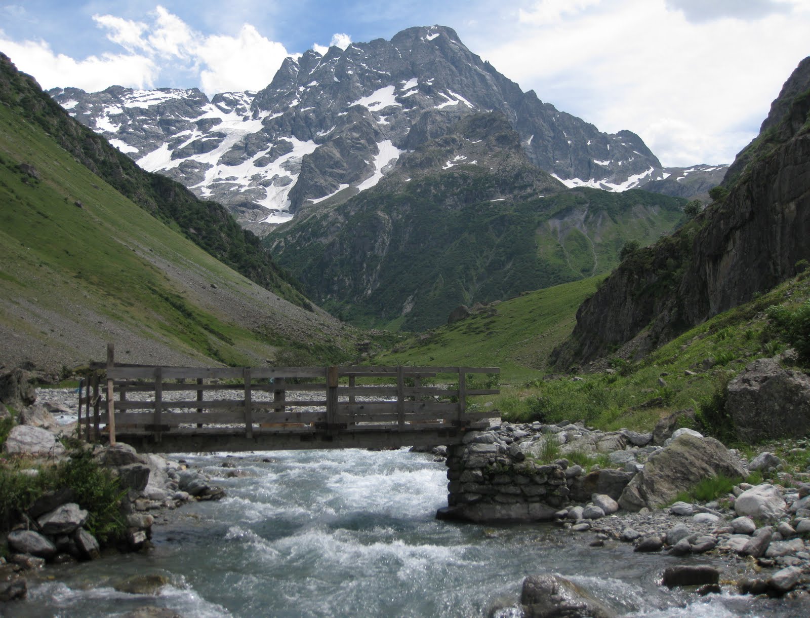
The trek began at the road-head west of the village of Vallouise, 20km SW of Briançon. We followed the path alongside a fast-flowing glacial stream through a pine-scented wooded valley in 30°stifling heat pausing frequently for rest and water!
 The Climbing Begins!
Eventually the climbing begins, up over stony ground and some scree and then compacted shale (dodgy when wet) to the first of 2 cols: the Col de l’Aup Martin (2761m), the highest point on the GR54. Here the temperature was mercifully comfortable although we knew the heat would return on the descent. A short traverse over scree led to the Pas de la Cavale (2735m) en route to which, an unavoidable spray waterfall gave us all a refreshing shower!
 Traversing Between the Cols
There then followed the first of several long weary descents steeply down to the grasslands of the Vallée de Champoléon and the first night’s accommodation at the Refuge du Pré de la Chaumette, a 62-bed mountain refuge at 1790m. This hut provided excellent facilities, good food and was constantly surrounded by marmots which provided a soundtrack of chirps and whistles to this welcome alpine fastness.
Day 2
Yesterday’s 2-col sweetener was trumped by today’s 3-col roller-coaster ride. An early start gave us shade and welcome coolness for the climb up the Vallon de la Pierre up switchbacks to the first high pass of the day: the Col de la Vallette (2668m). The path drops steeply from here, but not for long, before crossing a grassy valley to the Col de Gouiran (2597m).
 Col de la Vallette
Some lingering snowfields and a charming lake provided some scenic interest and the traverse to the second col took only 45 mins. The descent from this col is more straightforward than the previous ones and crosses a series of eroded shaley ribs before climbing to the Col de Vallonpierre (2607m).
 Col de la Vallette From Col de Gouiran
Much of today’s route circumnavigated the distinctive peak of Le Sirac (3441m) which looms above this last col. We resisted the good doctor’s exhortations to throw in an alpine ascent of a snow peak into our itinerary and enjoyed the spectacular views instead! We then descended steadily to the delightful, if crowded, Refuge de Vallonpierre standing on the edge of the glass-like Lac de Vallonpierre.
 Le Sirac
After a break for lunch we continued down into the green wooded Vallée du Valgaudemar and our second night’s accommodation: the Refuge du Clot, a homely 50-bed hut surrounded by trees at 1400m. Another excellent meal, hut guardians Pierre and Caroline and some very friendly chickens (you had to be there) all combined to make a memorable evening. We even saw the only chamois of the trek – albeit a distant speck high on the valley wall!
 Le Sirac From the Head of the Vallée du Valgaudemar
Day 3
Our third day began with an easy valley walk for 2 hrs before stopping for coffee and croissants at the only permanent settlement we came across, the small outdoor activity centre of La Chapelle-en-Valgaudemar. A further hour along the valley floor to Villar-Loubière and we could put it off no longer: the 4hr hot, steep and dusty 1500m slog up to the Col de la Vaurze (2498m). This was definitely the crux of the whole week! The only respite was a brief drinks stop at the well-placed Refuge des Souffles (1975m).
 Col de la Vaurze - the Crux!
There followed an interesting traverse across the upper valley headwall before more interminable switchbacks brought us to the Col de la Vaurze. From here we looked directly down on our night’s destination, Le Désert-en-Valjouffrey (1255m) nestling in the valley below – but it would still take another 2hrs to reach the hamlet from the col.
 The Descent to Le Désert
The Gîte le Désert provided basic accommodation but the highlight of the stop-over was definitely the €1.20 a shot whisky the good doctor and I imbibed ourselves with for much of the evening whilst trying to work out why you can’t see the dark side of the moon (you had to be there)! Most agreeable.
 Le Désert-en-Valjouffrey
Day 4
Following 3 big days, the walking was about to become a little easier and the days shorter as we entered the western part of the Écrins National Park. The scenery also becomes a little softer and the cols a little less austere. From Le Désert, we climbed in early morning comfort and on a good path to the grassy Col de Côte Belle (2290m) before descending through stands of alpenrose and pine forest to the village of Valsenestre (1294m).

The View South From the Col de Côte Belle
Beautiful and idyllic in mid-summer, the hamlet’s summer residents desert the place for winter before snow and avalanches cut off the valley! The very comfortable 25-bed Gîte Le Beranger provided excellent rooms, facilities and food for our valiant band of trekkers. The afternoon off was most welcome!
Day 5
Having originally planned to cover the trek in 6 days, we decided to combine the last 2 relatively easy days into one last big day. Although tiring, this would give us a full day off at the end of the trek for some welcome respite and maybe even lunch in Briançon! We started by returning along the previous day’s route for half an hour before climbing up through grass, then rock, and finally a steep shale cone to the Col de la Muzelle (2625m).
 Col de la Muzelle
Much of this was achieved in welcome shade and a cool breeze before the temperature started rising again as we descended over snowfields (nice nose-dive Toity!) down into a grassy valley to the Lac de la Muzelle and its attendant Refuge de la Muzelle.
 Col de la Muzelle From the Muzelle Refuge and Lake
Just before reaching the refuge we turned left for the 90-min climb up switchbacks to the Col du Vallon (2531m) our last high pass of the week. Soaring eagles and distant views of snowy peaks entertained us as we plodded ever upwards. There followed a long and twisting descent to the blue-green waters of one of the highlights of the whole GR54, the picturesque Lac Lauvitel (1540m). We just had to stop here in this sublime setting - the girls went for a swim and the guys paddled and everyone sunbathed (like we really needed more sun)! From the lake, a short 30 min descent brought us to journey’s end and a waiting car at the village of La Danchére.
 Lac Lauvitel
Overall, we covered 95km and climbed 7260m! This is definitely the most challenging – and rewarding – part of the GR54 and we were not disappointed. If you are planning to check it out, the GR54 is usually attempted between mid-July and late September when snow and ice are normally no longer a factor. However, some isolated patches of late Spring snow may be encountered and for that reason it is prudent to consider carrying an ice axe if travelling early in the season. Otherwise, you can expect very warm weather (hot in the valleys) with the occasional afternoon thunderstorm. Oh, and have plenty of Radox waiting at home for when you get back!
 Approaching the Col de la Muzelle
Check out my future plans for similar walks on: http://www.hillways.co.uk/alpine/alpine.htm
 Subscribe To This Feed
No comments:
Post a Comment