About Me

My photo
Hello! My name is Keith Gault and I've been tramping the hills of the UK and further afield for over 40 years now. This blog records some recent hill days undertaken either on my own, with friends, or with clients under my guided hillwalking Company: Hillways (www.hillways.co.uk). I hope you enjoy my diary; please feel free to comment on any of the walks. I will respond to any direct questions.

Tuesday, 15 July 2014

Glencoe 2014


Bidean nam Bian

Lynn had decided that being stuck on 63 Munros was getting tedious so a short visit to Glen Coe would be just the trip to get things moving.   Two Munros a day over 4 days would soon banish the staid 60s and make a serious start towards achieving the 100 mark!

Buachaille Etive Beag


Stob Coire Raineach

A 2hr drive from Edinburgh and we were on our way up the excellent new path that leaves the A82 just E of The Study.  The path heads towards the glacial U-shaped trough of the Lairig Eilde for ½Km where you fork left at a junction and start the climb.  The path ascends the grassy hillside to the bealach that splits the 2 Munros on the Buachaille Etive Beag ridge.  Here we entered cloud and rain which ensured we saw little of the subsequent ‘out-and-back’ traverse of the ridge to Stob Dubh (958m; black peak).


Stob Coire Raineach

Returning to the bealach, the cloud lifted and we started to get sporadic views of the surrounding mountains during the short climb to our 2nd peak: Stob Coire Raineach (925m; peak of the bracken corrie).


Cloud Lifting Above the Lairig Gartain

The return to the bealach and thence back down to the car was mercifully quick given the pretty average weather but we had at least moved Lynn off No 63 and achieved 2 summits in less than 4hrs!

Aonach Eagach


Aonach Eagach

The most challenging hill day in Glen Coe - by some margin - is the traverse of the Aonach Eagach.  This notched ridge is a serious undertaking in any weather and demands respect and caution by all who venture along it.


Glen Coe From the Climb Up Am Bodach

Leaving the car in a lay-by opposite Loch Achtriochtan, we walked up the glen to the parking area just west of Allt-na-reigh where a twisting path strikes steeply up the SE ridge of Am Bodach (943m; the old man).  You may well feel like the eponymous gentleman by the time you reach the summit but at least you will be rewarded with great views in every direction!


The View East Towards a Distant Schiehallion

Uppermost in your mind though is likely to be the view W towards the impending ridge.  It doesn’t look too troublesome from this point but the fun soon begins and just after leaving the summit of Am Bodach, the first of the problems is encountered - a sudden 20m drop.  This is negotiated via a snaking descent on steep ledges and ramps with a deal of exposure, particularly on the N side of the ridge.  Generally though, I find folk are too engrossed on locating the (ample) holds to worry about the view!


The Chancellor

The problems then ease temporarily and an easy ascent leads to the first Munro of the day - Meall Dearg (953m; red hill).  From here you get your first full view of the meat of the ridge although much of the detail is hidden by the intervening pinnacles.


 The Descent From Am Bodach

Suffice to say, there now follows up to 90 mins of, at times, intensive scrambling across no end of gullies, slabs and chimneys over numerous pinnacles.  Just before reaching the relative security of the final bealach, the ‘crazy pinnacles’ pose one last difficulty.  Some may opt - as we did, and I usually do - for a diversionary path on the N side of the ridge.  Whilst this by-passes the pinnacles themselves, it is very steep and requires great care.  It is not a place to be in the wet!


Lynn Taking it All in Her Stride!

Lynn - and me for that matter - coped admirably, however, and we were eventually spat out on that final col from where a steep but mercifully uncomplicated climb took us to the intervening summit of Stob Coire Leith (940m; peak of the grey corrie).
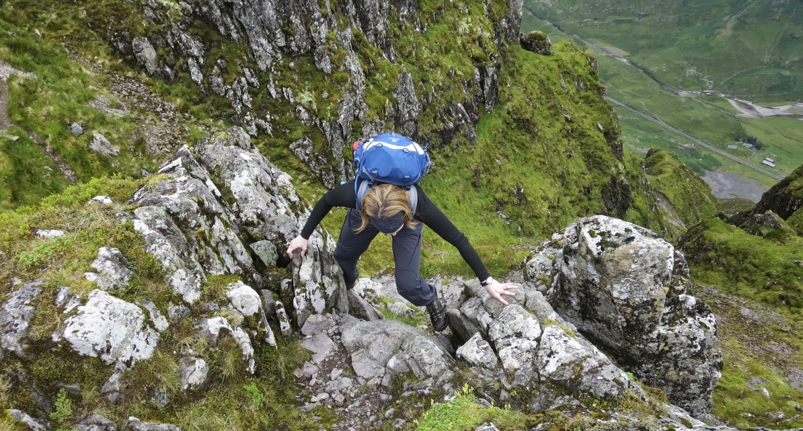

Bring it On!

From here, a fairly easy level walk leads to the 2nd Munro on the ridge: Sgorr nam Fiannaidh (967m; peak of the Fingalians).  Whilst the steep sides of Glen Coe contribute greatly to its rugged splendour, they also contribute greatly to the difficulties of descending from its summits!


You Get the Idea! 

Our descent to the car was anything but straightforward - 3000’ in a little over one Km!  Bouldery at first, grassy lower down with waist-deep bracken and always, always steep, it’s a real knee-breaker!  The accompanying fabulous views along and across the glen in late afternoon sunshine provided some compensation.  But the best reward of all was to reach the car.


Looking Up the Glen Towards Buachaille Etive Mor

That was one quality mountain day!

The Lost Valley

The very agreeable weather deserted us on Day 3 and we left early to get as much done as possible before the rain arrived.  We did well, but it still caught us late in the morning as we climbed out of Coire Gabhail - the Lost Valley - en route to our highest peak of the trip: Bidean nam Bian (1150m; pinnacle of the hills). 


The Lost Valley

From there onwards, there was precious little to see other than the occasional snow patch and steep plunging abyss back down into a hidden Coire Gabhail as we traversed down to the intervening bealach and up to our 2nd peak: Stob Coire Sgreamhach (1072m; peak of the dreadful corrie).


Looking Back Down the Valley

Returning to the bealach, the path down into the corrie is very eroded and can be treacherous in wet conditions.  Today a lingering frozen snow field added to our difficulties and we spent a lot of time carefully picking our way down to easier ground.


Bidean nam Bian From Stob Coire Sgreamhach

Eventually though, we intercepted our inward route and followed the path back down the Lost Valley arriving like drowned rats back at the car.  The rain continued for most of the night!

Buachaille Etive Mor


Buachaille Etive Mor

The weather returned to its earlier form on our last day and we were not troubled further by cloud or rain.  Parking at Altnafeadh, we climbed up the well-constructed path that now leads all the way to the skyline above the headwall of Coire an Tulaich.  The path remains on the W side of the corrie’s burn and avoids all the scree higher up.  Once on the corrie rim, it’s a straightforward and modest climb over the pink boulders to one of the most iconic peaks in Scotland: Stob Dearg (1021m; red peak).


Coire an Tulaich

Today, we were rewarded with a great view across Rannoch Moor towards a distant Schiehallion as well as back along the full length of this impressive ridge.


Across the Lairig Gartain Towards Bidean nam Bian

Retracing our steps to the corrie rim, we continued on over the intervening tops of Stob na Doire and Stob Coire Altruim before reaching the end of the ridge and our final Munro of the trip: Stob na Broige (956m; peak of the shoe).  The view from here down Glen Etive is particularly fine and everywhere you look there are mountains!


Stob na Broige

We returned to the bealach just E of Stob Coire Altruim before descending down another much-improved path that leads into the corrie and down into the Lairig Gartain.  An excellent path now leads NE through the Lairig and back to the A82 where a perilous ¾Km of road walking leads back to the start point - easily the most dangerous part of the day!


Glen Etive

So, a great few days in good company with a tidy haul of Munros and one of the Scottish Highlands’ finest ridge traverses.  What’s not to like?


This blog entry is dedicated to the memory of Hugo Crawford, brother, father and husband.  Although I never knew him, he loved the mountains as I do.  RIP.


Check out my plans for this summer at:  http://www.hillways.co.uk/  


Wednesday, 9 July 2014

Pyrenees 2014


This year’s Pyrenees trip saw me once again in the company of another fine bunch of air cadets from 633 Squadron, Air Training Corps.  This was to be a repeat of the 2011 hut-to-hut trek with a further attempt at the Pyrenees’ 3rd highest peak, Mt Perdido which thwarted us last time.


 Mt Perdido (3355m)

We started, as before, from the French village of Gavarnie, 2½hrs SW of Toulouse,  hoping for fine weather in early July.  Alas, this was not to be and the 5-day trek was peppered with variable cloud, frequent rain showers and mild, rather than hot, weather.

Day 1 - Gavarnie to the Sarradets Hut


Pic du Marboré From the Sarradets Hut

Indeed, Day 1 dawned cloudy and wet which forced a change (several in fact) of plan and a shortening of the day by positioning the vehicles above Gavarnie at the Col de Tentes (2208m).  Continuing up the disused road for 20mins to the French/Spanish border at Port de Boucharo (2273m), we were now in thick cloud and rain - an inauspicious start to our summer trek!


Sarradets Hut

Thankfully, things started to improve once we left the road and started traversing high above the Valle des Pouey d’Aspé  below the towering cliffs and snowfields of the Taillón.  Then we encountered the first of several snowfields of our own that forced an earlier introduction to crampons than we were expecting!  Reassuringly, everyone got on well with what was to be an essential piece of equipment for the days ahead.


Brèche de Roland 

The crampons stayed on for the climb up to the Col des Sarradets and the short traverse to our first night’s accommodation, the 57-bed Refuge des Sarradets (2567m).

Day 2 - Sarradets Hut to the Goriz Hut


Climbing up to the Brèche 

We awoke to clear skies and stunning views and donning crampons from the start, spent the first hour climbing the steep snow slopes to the impressive Brèche de Roland (2807m).  This 100m high gap in the frontier ridge resembles a missing tooth in the skyline and is an impressive landmark.  It was cold and draughty today though, (as it usually is in all fairness) so it was not a place to linger long.


Approaching the Brèche

We descended - steeply at first - on the Spanish side and linked the patchy snowfields together to ease travel as we continued down to the Narciso Plain where we were finally able to dispense with the crampons.  Here we saw the first of several chamois (or izard) we were to encounter on the trip.


Pyrenean Chamois or Izard

From the plain, we headed east, climbing the short way up to the Cuello del Descargador (2495m) from where our onward route finally became clear.  A series of ups and downs took us, without difficulty, across the Plana de San Ferlus and a further col, the Cuello de Millaris (2467m), before entering the picturesque grassy fold of the Circo de Góriz from where we descended to our home for the next 2 nights: the 90-bed Refugio de Góriz (2170m).  Here, we all ate well, slept badly and otherwise filled in time as best you can in high mountain huts!


Góriz Hut

Day 3 - Mt Perdido

Overnight rain cleared and it seemed that the weather was going to give us our best shot at our mountain.  An early start further enhanced our chances of success and we were soon climbing up above the hut over assorted rock bands, grassy terraces and rockfall with the impressive chasm of the Ordesa Canyon spread out far below us.


The Ascent of Mt Perdido

Almost 3hrs from the hut we crossed a final rock band to reach the half-frozen mountain lake of Lago Helado (3000m).  Here we had some food, donned crampons and dressed for the coming cool and windy conditions.


Scrambling up Another Rockband

Unlike last time, we stayed within the snow couloir and followed the established snow trench of previous climbers up the steepening slopes.  Everyone did really well given their lack of previous experience and steady plodding, careful footwork and sound technique brought us to the top of the couloir at the broad saddle from which we knew the summit would be ours!


In the Snow Couloir

And so it was just 10mins later that 10 of us stepped on to the summit rocks of the expedition’s long-awaited goal, the cold and very windy 3rd highest mountain in the Pyrenees: Mt Perdido (3355m).  The summit cross has disappeared but otherwise the view was the same as on my last visit - zero!  Helene rallied her troops for photographs various and even managed to present a Duke of Edinburgh’s Silver Award to Marianne - probably a first for Perdido!


The Summit!

After much elation and relief, we headed down, descending ever so carefully the same way down the snow couloir to Lago Helado and thence back down to the Góriz  Hut.  Twenty minutes out, the rain started and we arrived back wet but happy and ready for another Góriz night!


Looking up the Snow Couloir From Lago Helado

Day 4 - The Ordesa Canyon


Ordesa Canyon

Our longest day was to see us descending the entire 13Km length of this 1000m deep vertically-sided trench through which the glacial waters of the Rio Arazas tumble over a series of spectacular waterfalls.


Gradas de Soaso

The first hour saw us descending steeply as the GR11 path followed a series of zig-zags cut into vertical rock bands that form the infant canyon’s headwall.  Once down at the base of the Circo de Góriz (1880m) however, it was plain sailing all the way as we followed the well-used path/track that traces the canyon floor.  The way is punctuated by a series of stunning cascades notably the Gradas de Soaso, a series of broad steps, and the Cascada del Estrecho where the river plunges down deep chasms in the rock.


Deep Within the Canyon

The highlight for many, I’m sure(!), was the short stop at the café/shop at the Pradera de Ordesa where Magnum ices were gleefully consumed and the weariness of the journey set aside, albeit temporarily.


Bujaruelo Valley & River Ara

Then it was back on the GR11 which we followed to the mouth of the canyon where it joins the Bujaruelo Valley at the Puente de los Navarros.  Here, a vehicle track winds northwards beside the noisy Rio Ara and we followed this for just over 3Km to our long-awaited return to soft furnishings and hot showers at the always-treasured hostel facility at Camping Valle de Bujaruelo (1250m).  There followed a good night’s sleep all-round I think!

Day 5 - Bujaruelo to Gavarnie


Bujaruelo Valley

Our last day’s trekking took us another 3Km up the Bujaruelo Valley to the beautiful stone arch bridge of Puente de Bujaruelo.  That was the easy bit!  Here we bade farewell to the GR11 and climbed up the steep valley sides through the trees and out on to the open scree slopes.


High Above the Bujaruelo Valley

The valley floor was soon far below us and the grassy valley of Lapazosa opened up ahead.  After pausing for a snack in the sunshine, we continued up the final slopes to our old friend, the Port de Boucharo (2273m), last seen in the cloud and rain on Day 1.  Today, we enjoyed some welcome blue sky and sunshine and spirits were high for the last (of many) photo calls!


Lapazosa Valley & Port de Boucharo
There just remained the short ‘stroll’ down the old road back to the vehicles and lunch in the sun down in Gavarnie.  We celebrated our successful trek in style with a nice meal in the relative sumptuousness of the Hotel de Londres in Luz St Sauveur -  a far cry from the distant memory of our mountain huts!


Valle des Pouey d’Aspé

Despite the changeable weather and occasionally challenging terrain, it was a very enjoyable - and successful - trek.  Once again, it was a privilege and a pleasure to be in the company of some wonderful young people who were prepared to put themselves out for others.  They walked over 60Km/40miles and climbed over 3000m/10,000’ enduring both physical and mental hardship to raise a significant sum of money for Parkinson’s UK and Swindon Children Without A  Diagnosis.  Well done guys and many thanks to Helene and Dave for all their help along the way.

      
Deep in the Ordesa Canyon Beech Woods


Check out my plans for this summer at:  http://www.hillways.co.uk/