About Me

My photo
Hello! My name is Keith Gault and I've been tramping the hills of the UK and further afield for over 40 years now. This blog records some recent hill days undertaken either on my own, with friends, or with clients under my guided hillwalking Company: Hillways (www.hillways.co.uk). I hope you enjoy my diary; please feel free to comment on any of the walks. I will respond to any direct questions.

Saturday, 26 February 2011

Ben Nevis – A Winter Ascent

This weekend saw a quick return to Fort William to introduce Philip from Holland to the delights of a Scottish winter mountain ascent. He decided to begin at the top and elected to make the mighty Ben his first conquest of a Scottish peak – and in winter! My Dutch was no match for Philip’s English (fortunately) and we only lost ourselves in translation once. Philip seemed unusually unimpressed when I told him that sea eagles could now be seen in Scotland. He thought I was talking about seagulls!

Sunshine in Glen Nevis

Following a milder – and wetter – week, the snow has receded up the mountain during the past week and the lower half of the mountain was clear. This enabled a relatively quick ascent to the Red Burn crossing and no real levels of snow were encountered until about 900m. The crampons came on soon after and the cloud came down to ensure a completely different atmosphere and ambience from the sun-lit glen below.

Approaching the Snowline

The summit arrived after 3¼hrs together with assorted climbers and walkers who were milling around as if waiting for the clearance that never quite came. A lone snow bunting provided added interest but it was not a place to linger long on this day. We headed down, breaking cloud half-way down the zig-zags and finished the day in warm sunshine and with maybe, just maybe, a slight hint of Spring in the air!!!

Spring is in the Air (Perhaps)!

Check out my future plans for this winter on: http://www.hillways.co.uk/winter/winter.htm


Friday, 18 February 2011

Lochaber – Winter Skills

View From the Ben!

The last week has been spent in the sometimes wild, often wintry, but always interesting mountains of Lochaber. This area of the West Highlands, based around the rather grim, if useful town of Fort William, is home to 4 of the 9 highest mountains in the UK, including the highest: Ben Nevis. It also hosts one of the most picturesque glens in the country: Glen Nevis, a major ski complex, many, many Munros and the stunning defile of Glen Coe. The height of the mountains and the advantage of mountain uplift from the Nevis Range gondola and chairlifts make this an excellent venue for winter skills and is an annual entry on the Hillways calendar. On this trip, Dave was returning for a refresher whilst Sue was trying her hand for the first time in the noble art of winter mountaineering!

Descending Ben Nevis

Whilst I wouldn’t normally start with the biggest day first, promising weather coupled with an unpromising forecast encouraged us to climb Ben Nevis on Day 1. We were not disappointed. A dry day with a high cloudbase and a generally kind wind enabled us to ascend the Tourist Route fairly easily, pausing to don crampons just above the half-way point, and continue to a summit wrapped in mist and deep in snow. There was no view from the top, but the clouds parted early in the descent to give us great views of the upper part of the mountain and a glimpse of the precipitous north face with its 600m/2000’ cliffs. The whole day took 7hrs, a creditable time given the conditions, and it gave us an ideal introduction to the week’s activities.

High Point of the Week!

Day 2 was dreicher than dreich with cloud, rain and snow filling the view out of the window to such an extent that a day in the classroom met will all-round approval! It proved to be time well-spent though; the passing horrors outside and frequent cups of exotic infusions (Sue) and tea (Dave) bearing witness to informed, entertaining and illuminating discourses from yours truly on everything from how to survive an avalanche to the origin of the Ordnance Survey! The relative merits of fish pie compared to steak casserole may also have crept in at some stage....!

Day 3 saw us ascending the Nevis Range gondola (enclosed) and chairlift (distinctly unenclosed) to over 900m up the northern flank of Aonach Mòr.

Tight Rope!

Shrouded in mist, we spent the next 5hrs inspecting the snow pack, peering over massive cornices, and striding off (as much as you can in soft snow) on compass bearings determined by Dave and Sue’s (very) recently acquired navigation skills! Much to their credit, and in near white-out conditions, they located the diminutive snow-covered pile of stones that does for the summit cairn of the UK’s 8th highest mountain: Aonach Mòr (big ridge; 1221m). We continued south for a further 1Km until the intimidating snow-girt cliffs of Aonach Beag loomed out of the mist. We roped up for the tricky steep ascent through ice-caked boulders and on to the UK’s 7th highest mountain: Aonach Beag (small ridge; 1234m). This fine mountain lacks any marker at all in winter other than a point on a snowy cone that you judge to be higher than the rest! I probably choose a different point each year!

Approaching Aonach Beag

The limited time available until the last gondola down forced a bit of a route march upon us for the return. However, we still found time to peer over the cornices above Coire an Lochan and enjoy stunning views over the Great Glen before removing crampons, stowing ice axes and descending serenely to the valley floor.

Day 4 started bright and sunny and promised clear conditions for a traverse of the westernmost Mamores. However, danger signs of troubled times ahead soon became evident as we looked up to see clouds flashing over the skyline and storms of spindrift swirling over the ridges.
Sue Mans Up!

Sure enough, as we climbed above the tree-line up the steep, awkward and snow-covered flank of Mullach nan Coirean’s north ridge, we began to be bombarded by gusty winds and eye-stinging spindrift! Progress became wearingly-slow and a decision to retire gracefully was as sensible as it was inevitable. Interestingly, a pair of climbers on an adjacent ridge whom we had been watching battling against the spindrift had clearly come to the same conclusion. Reassuringly, the Scottish Avalanche Information Service (SAIS) forecaster for Lochaber that day also commented in his daily blog http://saislochaber.blogspot.com/ on the number of parties returning early from Ben Nevis due to the difficult conditions.

Fresh Snow in Glen Nevis

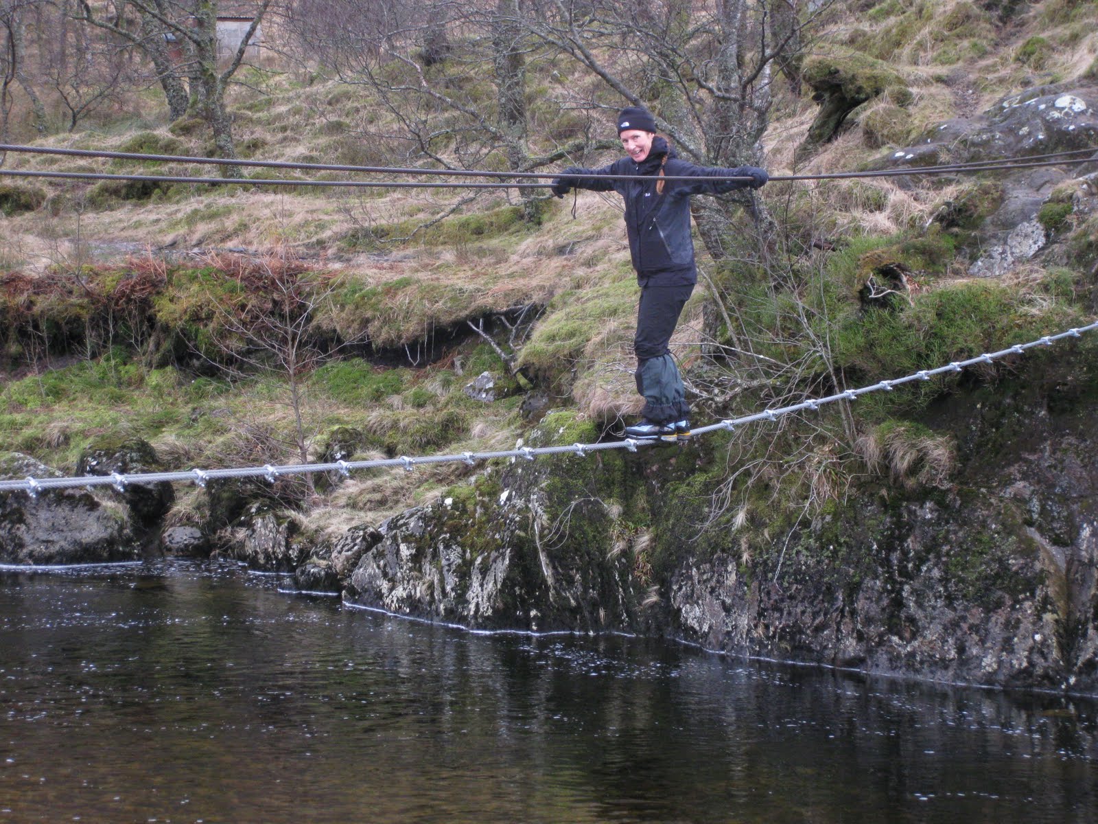
Day 5 was spent at lower altitudes, walking up Glen Nevis to visit the ‘rites of passage’ 3-wire bridge and spending the afternoon practising micro-navigation skills above Fort William. Sue distinguished herself by deftly negotiating the bridge with great aplomb – no sign whatsoever of clenched fists (or anything else, for that matter)!

That Bridge!

We squelched over to get up close and personal to the always impressive Steall waterfall before returning back over the bridge. The micronav went very well during the afternoon with every insignificant contour line wiggle successfully located in the otherwise featureless bog!

Man on a Mission!

Day 6 saw bright sunshine, blue skies and cold, clear air. We took the Nevis Range gondola up to the top station on the northern flank of Aonach Mòr and practised various set pieces covering examination of the snow pack, snow belays and ice axe arrests. The latter provided welcome entertainment to the passing skiers and snowboarders against a backdrop of snow white peaks stretching away to the far north west and distant Kintail, Torridon and Skye.

Winter Skills

All in all, we enjoyed a full week of winter skills in an excellent location well suited to the winter mountaineer!

Check out my future plans for this winter on: http://www.hillways.co.uk/winter/winter.htm


Thursday, 3 February 2011

The Lake District – Mountain Leader (ML) Training

Summer Mountain Leader Training

Memory-jarring early starts from opposite ends of the country brought Dave and I together in the Lake District this week for 3 days of summer mountain leader training prior to his ML assessment next month. The term ‘summer’ is a relative term at this time of year of course and so it proved as the full spectrum of UK February weather descended upon us and helped fully concentrate our minds!

Day 1: The Lion & The Lamb – Ropework Skills on Helm Crag

Hot-foot from the M6, we chose the model mountain of Helm Crag (405m) to practise some navigation, group management skills and ML ropework. Sitting modestly above Grasmere, this shapely wedge is a popular landmark with it’s distinctive summit rocks long ago christened the Lion & the Lamb.

Helm Crag

A good, well-marked path climbs comfortably up through bands of crags and on to closely-cropped grassy slopes that lead to the narrow, if short, summit ridge. A landslip has created a rocky trench above which 2 sets of rock pinnacles guard each end of the summit ridge; the southern formation earning the big cat/small sheep sobriquet when seen from the valley.

Helm Crag - Summit Rocks

The rocks provided an ideal spot for Dave to practise his deft rope skills sheltered from the biting wind. The entertainment was greatly enhanced by the surprising and impressive sight of a peregrine falcon flying strongly against the wind immediately above us before diving out of view! After expending his repertoire of direct and indirect belays, Italian hitches and abseil techniques, Dave pronounced himself competent. I agreed (naturally) and by way of some navigation legs, we duly returned to the valley floor via some conveniently placed ring contours and well-concealed ruins whilst discussing everything from access legislation to map scales!

Day 2: You’re Only As Good As Your Last Sheepfold!

Atrocious weather created the ideal conditions for Dave to get to grips with a day of micro-navigation: navigating short legs using map, compass and pacing. It is a key element of the summer ML syllabus and one that catches many folk out. You cannot practise it enough! Loughrigg Fell (335m), a scenic area of low hills, hummocks and miniature water features immediately above our base in Ambleside, proved to be an ideal location for our activities - particularly in the cloud.

Should be a Gate Somewhere Around Here....

During the course of this wild, wet and windy day, Dave successfully negotiated all that I (and the weather) could throw at him by way of insignificant contour shapes, sheepfolds and tiny tarns! This was no mean feat in appalling conditions and in a discipline requiring concentration, accuracy and excellent map-reading skills. He found every one of the chosen points and was still going strong when the mind of this observer had long ago turned to thoughts of steak and chips and a long, lazy glass of red........

Blencathra From High Rigg

Day 3: More Ropework; More Nav!

The final morning saw us in greatly changed weather with snow on the tops and a bitter wind blowing storm clouds our way. Again, relatively low ground provided all we needed – grassy hummocks, tiny water features and small crags. We chose High Rigg (355m) above the delightfully named St John's in the Vale. You don’t always need to go to the tops of the mountains to achieve your aims (which was just as well given this week’s weather)!

Storm Clouds Over Thirlmere

We beat the rain though, and consolidated all the previous days’ activities leaving Dave all set for the rigours of his ML assessment. He also managed to pick a likely looking spot for the family to go wild camping when they come back for their summer holiday – although I’m not sure if he’s actually told Paula yet............


Easedale


Check out my future plans for this winter on: http://www.hillways.co.uk/winter/winter.htm


Monday, 24 January 2011

Pentland Hills – Kip Skipping!

The Kips From Black Hill
My favourite amongst the shapely Pentland Hills is the distinctive conical ridge of West Kip (551m). Whilst the name derives from the Celtic word for pointed hill (caep) this miniature mountain alternates in appearance from being a sharp cone when viewed from either NE or SW, to a short flat-topped ridge (which is actually what it is) when seen from the NW or SE. The final approach to the hill, from whatever direction you choose, is guaranteed to be rewarding with steep grassy slopes rising to a delightful roof-top ridge wide enough for its traversing path but not much else! Notwithstanding these plaudits, West Kip is but one highlight of an excellent out-and-back walk from the evocatively named hamlet of Nine Mile Burn on the A702 Edinburgh – Biggar road. The spot is 9 old Scots miles from Edinburgh (about 11 miles in new money)!

West Kip From Monks Rig

This 11Km route follows clearly-marked or good quality paths throughout and loses nothing in forcing you to return via the outward route. My only problem earlier this week was the skin-stripping wind that came in off the North Sea and took no prisoners as it scoured these exposed tops! It really dominated the walk and at times impeded progress to the point of frustration – probably not helped by the absence of my gore-tex jacket! Nevertheless, it was – and is – a cracking wee walk and took just 3 hrs to traverse West and East Kip, Scald Law and South Black Hill before returning me, sand-blasted but fulfilled, to Nine Mile Burn!

West Kip From South Black Hill

From the car park opposite the line of cottages now mercifully by-passed from the speeding traffic, follow the signpost to Balerno, through the kissing gate. Follow the dry stane dyke around the field eventually crossing a stile on to the open grassy shoulder known as Monks Rig. On the way you pass the Font Stane, a shaped piece of local rock with a sculptured recess thought to be the base for a cross, now long gone. Coins in the recess are evidence that the age old tradition of making an offering at the cross continues to this day! This is the course of the old Monk’s Road between Newhall Monastery and Dunfermline Abbey. Continue over the flat top of Cap Law beside a distinctive clutch of wind-sculpted larches from where a scenic vista opens up.

East Kip, Scald Law & South Black Hill From Cap Law

Now you can see the shapely cone of West Kip and the rest of the day’s hills that encircle the hollow of Eastside Farm and its eponymous burn. Here, the wind really took hold and it was head down to the base of West Kip before the short, sharp pull up to the summit. This would normally be a great place to linger but not today! It was smartly down (as all descents from West Kip are) and then up and over East Kip (534m) before descending to Cross Sward, the grassy col between the Kips and the main Pentland ridge. From here, a clear path takes a rising traverse up to the Pentlands’ crowning summit, complete with white trig point and expansive views - Scald Law (579m).

The View From West Kip Along the Pentland Chain

Braced against the relentless wind I ran down to South Black Hill (563m) which is effectively the SW Top of Scald Law and is adorned by a pile of red trachyte stones arranged in a shallow circular retaining wall. It didn’t offer much shelter today so it was quickly back down to Cross Sward and over the Kips, running with the wind back over Cap Law and down to the merciful shelter of Nine Mile Burn and the waiting car!

West Kip


Check out my future plans for this winter on: http://www.hillways.co.uk/winter/winter.htm


Thursday, 20 January 2011

MLTA Workshop – Winter Mountaineering

Twelve months on and it was back to Fort William for another Mountain Leader Training Association (MLTA) (www.mlta.co.uk) workshop with British Mountain Guide Tim Blakemore. Tim runs a series of workshops at this time of year on behalf of the MLTA aimed at instructing/refreshing mountain leaders on useful topics. Apart from the obvious benefit of such training, participants also receive points towards their continuing professional development (CPD) a newly-introduced requisite for maintaining one’s mountain qualifications.

This was just a one-day workshop but Tim still managed to get a lot across to our group of 6. The main aim was to explore the grey area between non-technical mountain leading and winter mountaineering. This entailed practice in leading clients on steep ground using ‘short roping’ techniques. The leader and followers are tied on to the same rope with the former taking any spare rope around his body in coils. He then controls the distance between himself and the No 2 by holding or releasing hand coils. This technique enables a group to move steadily over difficult terrain without set climbing pitches and fixed protection.

Needless to say, it was a typically cold, blustery January day that we climbed into the Nevis Range gondola for the ride up to the top station. The biting wind and occasional snow shower ensured we all remained tightly wrapped in gore-tex all day! The crampons came on soon after leaving the top station, together with helmets, harnesses and ice axes. Splitting into groups of 2 or 3 we spent the day examining the snowpack, leading each other up and down steep ‘gnarly’ ground and looking at various ice axe belays. There was some invaluable ropework for us non-climbers and some discussion on the effectiveness of ice axe arresting. The empty promise of a nice hot coffee (I forget from whom....) ensured we descended to the gondola station in plenty of time to beat the last ride down and a short de-brief saw us on our way before darkness.

A big thank you to Tim (http://www.northernmountainsport.co.uk) for giving up his nice French alpine apartment for the joys of Fort William so that we could fill in our knowledge gaps and improve our experience. He’ll be back next year, and so will I!


Check out my future plans for this winter on: http://www.hillways.co.uk/winter/winter.htm


Thursday, 23 December 2010

Pentland Hills and Winter Skills!

Just 15 Minutes From Edinburgh!
Friend, bush craft expert and survival guru Nigel popped up for a few days before Christmas just in time to feel the full icy blast of our on-going winter. The idea was to practise some winter skills techniques and we were originally going to head for the Cairngorms where we knew snow would be guaranteed. Needless to say, these days if it’s snow you want, all you need do is open your front door! So it was last week and we forsook the dodgy drive up and down the A9 for the short trip to the Edinburgh city limits where we found all we needed on the steep northern slopes of Caerketton Hill at the north-eastern end of the Pentland Hills.

Grade 1 Ground - Pentlands Style!


Some of the approach lanes to the Pentlands have been difficult to negotiate during the snowy weather but the car park at Swanston has remained open and duly served as our starting point for each day’s activities. Within 10 mins of leaving the car we were ankle-deep in powder snow which overlay a hard icy base. Higher up we encountered some surface ice patches and areas of freshly created soft windslab. These contrasting snow conditions gave us just what we needed to rehearse a string of winter techniques including ice axe and crampon work, snow belays and avalanche assessment.

Nigel Busy Burying His Ice Axe

On leaving the summit of Caerketton Hill we came across stark evidence of nature at work. Amongst the myriad of footprints, ski and animal tracks in the soft snow, Nige was quick to spot – and identify - something different. A raptor, maybe a kestrel, had swooped down and taken a small rodent or something similar leaving a clear imprint of its wing feathers just at the point where the unfortunate prey’s tracks came to an abrupt and ominous end! Try clicking on the photograph to enlarge it and you should see the details.

A View to a Kill

On Day 2 we climbed straight to the base of one of the crags immediately below the summit of Caerketton Hill and took turns leading up a steep snow gulley that we had spotted the previous day. It was good to get the rope out; it proved particularly reassuring for the near-vertical ice field that we found at the top end of the gulley! In the absence of any recognised named climbs on this part of the gently rolling (!) Pentland Hills we christened it Supermarket Gulley. The previous day whilst surveying the view over Edinburgh we somehow got into an amazingly banal unbloke-ish exchange of views on the merits of different supermarkets! You can see quite a few from here!! It’s alright, I don’t expect you to understand - you had to be there!!!


Nigel Leads the Way up Supermarket Gulley

On Day 3, we climbed yet another steep gulley, topped Allermuir Hill and then finished off with some interesting micro-navigation looking for insignificant snow-covered hummocks, ring contours and stream beds using map, compass and pacing. All very enjoyable – and successful. In the end, we achieved everything we wanted to and Nigel left a happy and contented man. I suppose we did miss out on a night in a snowhole but when I suggested it all I could see of him was his back fast disappearing off in the general direction of the Swanston clubhouse. Beer and chips seemed to offer a more appetising alternative to a night in the snow! I ask you! Maybe next time Nige?

Tea O'Clock!

Check out my future plans for this winter on: http://www.hillways.co.uk/winter/winter.htm


Sunday, 5 December 2010

Arthur’s Seat – A First Winter Ascent!

Arthur's Seat

Having spent most of the past week with a shovel in my hand constantly digging my way to the outside world, today it was time to get the winter gear out and enjoy a hill-walk in the snow. The distinctive volcanic mound of Arthur’s Seat (251m) can seem like the middle of the country (as opposed to the middle of Edinburgh) at the best of times. Cover it with ice and a healthy foot or two of snow and you very much are a million miles away from the surrounding streets of the city. Blue skies, clear air and bright sunshine completed the magical mix which ensured a superb couple of hours of winter walking.

Looking Across Salisbury Crags to Edinburgh

Such is the amount of snow that has fallen in these parts during the past 7 days, it was hardly surprising to see an avalanche warning issued for this wee hill a couple of days ago. Come the weekend though and the snow has consolidated pretty well and there’s a greater danger from snow falling from high rooftops in the city than on the steep slopes of Arthur’s Seat. The paths are all compacted snow now which is icy enough to make progress slow and thoughtful. The summit rocks are passable with care but if you have crampons and an ice axe, you will certainly benefit from using them. Avoid the steeper paths on the way down and try and stay on the softer snow to remain upright.

The Summit

On the lower slopes, sledgers and skiers mingled with walkers, dogs and children all savouring the wonderful winter experience that is a Sunday stroll on sun-kissed snow! Don’t worry if you didn’t get out this weekend, something tells me there will be many more opportunities before we get to see our back lawns again!

Global Warming On Hold!

Check out my future plans for this winter on: http://www.hillways.co.uk/winter/winter.htm